James McFarlane Land Survey, 1770
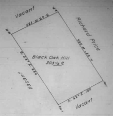 |
| James McFarlane Land Survey Map #3363, ordered on June 13, 1769, and executed on May 25, 1770. This survey was conducted for James McFarlane's New Purchase Application. Notice that the four corners of the tract are marked with a black oak tree, a white oak tree and two posts. The two posts were probably installed by the surveyor. This tract, called "Black Oak Hill" may have been named after the black oak at the corner of the tract. Originally recorded in Pennsylvania Survey Book M, Page 409. Replicated from microfilm at the Pennsylvania State Archives, Harrisburg, PA, Roll 28.24. |
 |
| James McFarlane Land Survey #3363, ordered on June 13, 1769, and executed on May 25, 1770. Originally recorded in Pennsylvania Survey Book M, Page 409. Replicated from microfilm at the Pennsylvania State Archives, Harrisburg, PA, Roll 28.24. |
James McFarlane's "Black Oak Hill" tract contains the later site of the Abbott farm. The Scott Township Warantee Map shows where James McFarlane's "Black Oak Hill" tract lay in relation to other tracts. See also the James McFarlane Land Patent and Richard Price's Land Survey for the adjacent lot.