Prehistory of the Abbott Farm Land
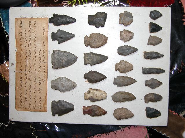 |
| Prehistoric Stone Artifacts found by Howard H. Abbott on the Edward Abbott Farm, Mt. Lebanon, PA, in 1900. Charles Page Collection. Click on the image for more information. |
The author, Ed Donley, is not a professional archaeologist, so this article may suffer from unintended bias on some issues about which the author is not sufficiently knowledgeable.
Imagine that you have been sitting on the Abbott farm land for the past 100,000 years. (See a painting of the farm from 1875.) You would have witnessed a gradual change in the climate, vegetation, animals, and humans until the early 1800s. Once Europeans settled in the area in large numbers, you would have seen a more rapid transformation. Each of the sections below includes a summary of information about each period and presents a speculative narrative of what you might have seen on the Abbott farm land. The dates for all periods are approximate and tentative. The dates assigned to periods occasionally change as new archaeological evidence or models arise.
The Wisconsin Ice Age (75,000 - 10,000 B.C.)
Over a million years ago, before the four ice ages of the Pleistocene Period, the Monongahela River flowed into the Beaver River and the Beaver River flowed north into a river system where the Great Lakes are now located. The Ohio River was a short tributary flowing northeastward into the Beaver River. During at least one of the ice ages, as the continental glacier advanced from Canada, it blocked the northward flow of the Beaver River and created the vast Lake Monongahela. The lake's tendrils reached up into all of the river and creek valleys in western Pennsylvania, eastern Ohio, and northern West Virginia. The shoreline reached an elevation of 1060 feet above sea level, just 80 feet below the Abbott farm. You could certainly see Lake Monongahela from where you were sitting on the Abbott farm site. Eventually, the lake overflowed the surrounding mountains and cut a channel westward along the present course of the Ohio River to the Mississippi River. This drained the lake and switched the direction of flow of the Beaver and Ohio Rivers to their present direction. This cycle may have been repeated several times. The age of Lake Monongahela is debated, between 22,000 and more than 788,000 years ago. [WVGES, 1999] [PITT Geology, undated] From this time onward, you would not see any significant changes in the terrain surrounding the Abbott farm. This occurred before humans arrived.
During the most recent ice age, the Wisconsin, on the Abbott farmland, you would have been either sitting in tundra vegetation with scattered stands of spruce and pine trees or sitting in an open spruce-pine forest1. The climate was colder and wetter than the present and there was less seasonal fluctuation. Long-term climate changes are usually caused by variations in the earth's revolution and rotation about the sun. [Kutzbach, 1981] The Abbott farm site could have been open tundra, tundra with scattered spruce and pine stands, or a spruce-pine forest with an open canopy. The open tundra would have consisted of short shrubs, grasses, herbaceous plants, and lichens, similar to the current vegetation of northern and western Alaska and northern Canada. Tundra soil would have been boggy because the underground permafrost prevented good drainage. If the climate was slightly warmer, the tundra would have contained scattered stands of spruce and pine trees. If the climate were even warmer, the Abbott farm site would be covered by a spruce-pine forest with an open canopy, allowing light to reach the forest floor. Coniferous trees use less moisture than deciduous trees, so that most moisture would remain in the soil of the open spruce-pine forest. The understory vegetation would be the same as in the tundra. [Larsen, 1980].
A wide variety of large mammals would wander past you on the Abbott farm land. Woolly mammoths (Mammuthus primigenius) grazed on the tundra. The long-nosed peccary (Mylohyus nasutus), a member of the pig family about the size of a small white-tailed deer, probably traveled in packs. Caribou lived in small herds, as they do today in eastern Canada. The woodland musk ox (Symbos cavifrons) was taller and had a more slender build than the modern musk ox, so it might have been adapted to a warmer climate. The elk-moose or stag moose (Cervalces scotti) was somewhat larger than our modern moose. Its body resembled a moose, but its face looked more like an elk. It had large complex antlers. Jefferson's ground sloth was about the size of an ox. It lived in the forests browsing on leaves, twigs and possibly nuts. The dire wolf (Canis dirus) was the size of a large gray wolf, but built more heavily with a large, broad head like a hyena's. It was probably primarily a scavenger. The giant beaver (Castoroides ohioensis), the size of a black bear, was an uncommon resident. These are all of the large mammals that lived in Pennsylvania at the end of the ice age, in addition to a variety of small mammals. Most of Pennsylvania's modern mammals lived during the Wisconsin ice age, but they lived further south where the climate and vegetation were similar to modern Pennsylvania's. [Kursten, et al, 1980]. In contrast to the great variety of mammals, plant species were much less diverse than that supported by the mixed hardwood forests of more recent periods. The river valleys, however, supported more varied plant life than the hills. [Carr, 1998]
Archaeologists are debating when people first arrived in North America. The continental glaciers were thousands of feet thick, so it would have been extremely difficult for humans to cross large expanses of glaciers. They would have been unable to find any food during the entire journey. So, many archaeologists argue that humans could not enter from Asia to Alaska until the glaciers began to recede in 10,000 B.C. Most archaeological sites date no early than 8000 B.C. However, many other archaeologists argue that immigrants arrived much earlier, possibly following the edge of the ice sheet in boats. These archaeologists recognize several dozen sites scattered across North and South America as having been occupied as long as 20,000 or 30,000 years ago2. One of these sites is Meadowcroft Rock Shelter on Cross Creek in southwestern Pennsylvania, with carbon dates undisputedly as old as 9000-11,000 B.C. and controversially as old as 18,000 B.C. Cross Creek flows into the Ohio River. The rock shelter is 25 miles southwest of the Abbott farm land. North America's early inhabitants were nomadic, so if you were an observer at that time, you might have occasionally seen Meadowcroft's occupants traveling through the Abbott farm land in pursuit of game, or berries and wild plants. Their lifestyle was similar to the Paleo Indians described in the next section.
Paleo Indians (earlier than 10,000 B.C. - 8000 B.C.)
Paleo Indians were sparsely scattered throughout North and South America. According to archaeological records3, Paleo Indians lived along Chartiers Creek, 3 miles west of the Abbott farm site. The landscape was still tundra or open spruce-pine forest.
The Paleo Indians were traditionally characterized as nomadic big game hunters, following herds of caribou and mammoths. [Haynes, 1966] More recent interpretations of the archaeological data suggest that they were more general hunters and foragers, exploiting a variety of large and small game animals, supplemented with fruits and wild plants. [Meltzer, 1993] [Custer, 1996] The typical spear point, in the Clovis style, was 2 to 3 inches long. Paleo Indians generally did not have permanent dwellings; although, there are a few exceptions, such as Meadowcroft4. They traveled in small bands, probably containing several dozen individuals, following the mammal herds and constructing temporary skin- or brush-covered lean-tos. The only locations that they were known to consistently revisit were the quarries from which they gathered stone for projectile points.
Many of the western Pennsylvania Paleo Indians' projectile points were made of chert from the Coshocton Formation quarries in eastern Ohio, 125 miles away, and the Onondaga Formation quarries in southern New York, 200 miles away. So, these Paleo Indians either traded with people from these areas, or traveled to these locations. [Gramley, 1988] [Lantz, 1984]
Paleo Indians had no cooking pots, so they must have roasted their meat on open fires. No sewing tools have been found, so they probably wore loose-fitting skins. They may have worn shoes, since a skeletal study of prehistoric feet shows evidence of shoes as early as 26,000 B.C. [Trinkaus, 2005]
If you were an observer on the Abbott farm during this period, you probably would have seen infrequent human activity. You might have seen a caribou herd appear from over the rise and then pass out of sight. A few minutes later, a band of Paleo Indians might have appeared from the same direction, clothed in their loose fur-covered skins to keep out the cold. They might have stopped at the spring on the Abbott farm for water and slept nearby for the night, quickly erecting lean-tos from nearby spruce boughs. But they would not stay for long. When the caribou herd moved on to feed on fresh tundra vegetation, the hunters would follow the herd. Since the Paleo Indian population was so sparse and since there were no quarry sites along Chartiers Creek, you might not see another group of people for years.
Archaic Indians (8000 B.C. - 1000 B.C.)
As the glacial ice sheet retreated further into Canada, the climate became warmer and drier. The mixed hardwood forests, that had retreated to South Carolina and Georgia during the Ice Age, moved northward at an average rate of about 1/2 mile per year. If you were an observer on the Abbott farmland, you would notice the spruce and pine trees filling in the tundra meadows, forming a continuous spruce-pine forest. Then gradually, hardwoods would displace the spruce and pine trees5. This transition continued throughout the Early Archaic period and was not complete until the Middle Archaic. Although, the dominant tree species was white oak6, the forest was more diverse than the previous spruce-pine forest. Most of the trees grew to full maturity7. See the Chapman Forest Web site for tree sizes in a mature forest in Maryland.
These massive trees were widely spaced, compared to trees in a young forest. Individual trees died after having lived for several centuries, leaving a hole in the canopy. Shrubs and saplings quickly sprouted on the newly sunlit forest floor. Beavers dammed up ponds that they maintained for a few decades until they had harvested all of the trees near their pond. Then they abandoned their sites and moved to new locations. The unattended dams deteriorated and the ponds drained. The pond water killed any forest seeds in the seed bank, so meadows formed in these abandoned areas which slowly grew back into forests over a couple of decades. Under the forest tree canopy, the density of the understory vegetation is a matter of dispute. The undergrowth may have been thick or quite open.8 The trees were not covered with moss and lichens.9
Most of the large Ice Age mammals became extinct by 10,000 B.C. due to climate change, human hunting pressure, or a combination of both. The animals that we now associate with Pennsylvania moved north with the mixed hardwood forest. Pennsylvania was populated by white-tailed deer, black bears, elk, moose, woodland bison, cougars, bobcats, gray wolves, turkeys, and most of Pennsylvania's current animal species. A 25-square-mile ring hunt in 1818 in pre-settlement Medina County, Ohio, included 17 wolves, 21 bears, and 300 deer with some deer escaping. [Howe, 1891]
The Archaic people probably lived in well-defined drainage regions in groups of up to 100 individuals. These groups alternated between winter and summer base camps, with transient spring and fall camps and year-round smaller hunting camps. They migrated between these seasonal camps scattered throughout the forest to exploit the food sources that varied with the seasons, such as berries in the summer and nuts in the fall. The smaller spear points and the variety of other stone implements for scraping, drilling, and grinding indicate that Archaic people adapted to their more diverse environment by exploiting more small game and plant food sources. Paleo Indians used stabbing spears (lances). But Archaic and Woodland period spear points were mounted on throwing spears launched from a spear thrower, also known by its Aztec name, atlatl [Witthoft, 1965] Spear throwers are sticks, made of wood or antler, between one and three feet long with a hook on one end and a handle on the other. The butt of the wooden spear shaft fits into the hook. The atlatl is held horizontally with the hook-end facing back over the shoulder and the spear shaft lying on the atlatl. The thrower swings the atlatl over his head like a fly fisherman casts a line, releasing the spear. The atlatl extends the effective length of the thrower's arm. This and other engineering factors enable a spear thrower to achieve a range of 200 yards -- as long as a bow and arrow. [Kleiner, 1999]
Some burial sites contain red ocher to color the body, copper items, shell gorgets, and ceremonial blades, suggesting that Archaic society had a class structure. Regional differences in style and trade in exotic goods, such as copper and shells, also suggests a social class structure. [Raber, 1985, p. 13] The remains of a few Archaic houses have been found. These were dome-shaped circular structures with a framework of wooden poles and covered with bark. [Kent, 1994]
Archaic archaeological sites are sparsely scattered throughout the hills around Mount Lebanon. Higher concentrations of sites are located in the Chartiers Valley around Bridgeville and Mayview. However, these perceived concentrations may be a result of more thorough archaeological excavations in the valley, rather than a reflection of the actual population distribution of Archaic people.10 These valley sites may have been occupied by the same people who frequented the Abbott farm site.
Early Archaic (8000 B.C. - 6000 B.C.)
The Early Archaic period was a transition between the Paleo Indian environment and culture and the Archaic environment and culture. At the beginning of this period, the forest was dominated by spruce, but by the end, the forest was dominated by oak. Native people adopted the Archaic lifestyle by the end of the Early Archaic period.
The Abbott farm had a spring feeding into Little Sawmill Run, so it would have been a good seasonal camp site. Howard Abbott found 26 projectile points in the plowed fields of the Abbott farm. Three of these have been tentatively identified as Early Archaic styles (projectile points 4, 5, and 9). So, this site was probably either a camp, the location of a seasonal food source such as a hickory grove, or a stopping point along a travel route. [George, 2004] According to Wilkins [1978], many Archaic hilltop sites were nut-gathering locales. Archaic occupants of the Abbott farm site probably lost these projectile points while hunting wildlife, while gathering nuts, or while doing chores around the camp site. Several of Howard Abbott's projectile points were unfinished (projectile points 12 and 13), so projectile point production was one of the camp activities for either the Archaic or Woodland occupants. Two lanceolate or drill points (projectile points 22 and 23) and two scrapers or flakes (projectile points 19, 26) suggest that camp activities could have also included leather, wood, and plant fiber processing for clothing, shelter, and tools.
The chert and flint used to produce these 26 projectile points came from a variety of sources. Some were manufactured from Onondaga chert (projectile points 3, 14 15, 16, 18, 23, 24, 26). Onondaga chert was formed in western New York and pushed into the Allegheny River valley by glacial action. The river washed chert pebbles downstream along the Allegheny and Ohio Rivers. Prehistoric people collected these pebbles from the river bed. People also collected chert embedded in the limestone stratum, called the Uniontown formation, exposed on the cliffs along Chartiers Creek and Little Chartiers Creek. [Eisert, 1974] At least one of the projectile points was manufactured from an exotic source of chert in Flint Ridge, Ohio, 140 miles from the Abbott farm. (projectile point 6) This was obtained through trade or long-distance travel.
Middle Archaic (6000 B.C. - 4000 B.C.)
In the Middle Archaic period, the environment was dominated by oak-hemlock forests. Some evidence suggests that a warmer and drier climate began in 7000-6000 B.C.; although, others claim that this climate change occurred later, at the beginning of the Late Archaic period.11
In the Middle and Late Archaic periods, resource procurement sites were primarily in the uplands, while base camps were on river terraces. [Cowin, 1991] If the local people followed this pattern, they would have procured resources, such as nuts, berries, and wildlife, in Mount Lebanon while maintaining base camps in the Chartiers Creek valley.
Four of Howard Abbott's projectile points have been tentatively identified as Middle Archaic, demonstrating that people continued to occasionally occupy the Abbott farm site during this period. (projectile points 1, 2, 10, 11) The Middle Archaic people's lifestyle was as described in the Early Archaic section.
Late Archaic (4000 B.C. - 1000 B.C.)
In the Late Archaic and Early and Middle Woodland periods, the forest was still dominated by oaks. Hemlocks receded in prominence due to the spread of a pathogen at about 2700±100 B.C. [Davis, 1981], or possibly due to a warmer and drier climate, if the later date for the onset of this climate change is correct. (See endnote 12.) The hemlock die-off permitted an increase in nut-producing trees. These trees provided additional food sources for humans and the species that they hunted. Oak-hickory forests dominated at first, followed by oak-chestnut forests. [Custer, 2001, p. 71] [Davis, 1983] [Joyce, 1988] The introduction of chestnut could have been due to a slower northward migration rate following the recession of the glacial ice sheet. [Davis, 1981, p. 151] Late Archaic populations were higher than previous periods for much of the eastern United States, possibly due to the increase in food from nut-bearing trees. (See endnote 11.)
Twelve of Howard Abbott's projectile points were tentatively identified as Late Archaic. (projectile points 1, 4, 9, 11, 15, 16, 18, 21, 22, 23, 24, 25) The abundance of Late Archaic projectile points at the Abbott farm could be due to the Late Archaic population increase. There could have been more people at the Abbott site, or the site could have been visited more frequently. An observer on the Abbott farm site would have probably seen more human activity during the Late Archaic period than in any other period until European settlement. You might see a group of families, consisting of a few dozen people, arrive at their seasonal camp in early fall. Some group members might make minor repairs on their dome-shaped houses that had been damaged since their last stay here, replacing some of the poles or bark coverings. Others gathered firewood in preparation for their first chilly night in camp. Once the camp site was established, most of the group went out to gather the fall crop of acorns, hickory nuts, beech nuts, and chestnuts. They sought out white oak acorns over red and black oak acorns, since they contained less tannin. Squirrels and other animals preferred white oak acorns, too, so people had to gather them early in the season. When the first acorns were brought into camp, some of the camp residents might begin soaking them in water from the spring, possibly after crushing the acorns first, to leach out the bitter, water-soluble tannin. After straining off the water, the sweet acorn flour might have been formed into cakes and baked to preserve it for future use.
Transitional Period
The Transitional Period marked the change between the Archaic lifestyle and the Woodland lifestyle. Transitional people in Pennsylvania lived along major rivers, including the Allegheny, Susquehanna, Delaware, Schuylkill and Lehigh Rivers. Unlike the Archaic people, who migrated between seasonal hunting camps in the hills, the Transitional people primarily remained along the rivers. From their riverside settlements, they would travel a hundred miles along the rivers in search of fish and riverside game. They cooked their food in rectangular soapstone vessels, unlike the Archaic people who must have roasted their meat. Since the Abbott farm is in the hills, three miles from Chartiers Creek and five miles from the Allegheny and Monongahela Rivers, the farm site was probably only visited infrequently by Transitional people. Soapstone pottery sherds are abundant along the Allegheny and Ohio Rivers, although the broad spearpoints that characterize central and eastern Pennsylvania Transitional cultures are rare along these Rivers. [Witthoft, 1953]
Woodland Indians (1000 B.C. - 1600 A.D.)
The climate and forest reached their modern conditions by 1 A.D. White oaks dominated the upland forest of southwestern Pennsylvania, mixed with a significant number of hickories, chestnuts, maples, hemlocks, beeches, and pines.
The Woodland period begins with the initiation of pottery-making. Pottery requires a more sedentary lifestyle. Pottery provided food storage secure from animals and it allowed people to boil their food in addition to the previous method of roasting. Woodland people lived in semi-permanent villages and gradually adopted farming.12 These villages were primarily located in the river and major stream valleys, such as along the three rivers and Chartiers Creek, where the soil is most fertile. After a few decades, the fields surrounding the village would lose their fertility and the villagers would have used up all of the nearby firewood. The villagers would abandon the site and move a few miles along the river or large stream. The fallow fields would become fertile again after a few more decades, so that the original site could be re-occupied. Villagers focused on planting and tending their crops in spring and summer. They foraged, fished, and hunted year round, but hunting intensified after the fall harvest. Woodland sites near the Abbott farm were concentrated in the Allegheny, Monongahela, and Ohio River valleys and the Chartiers Creek valley.13
Early Woodland (1000 B.C. - 300 B.C.)
Early Woodland people continued the economic base of the Late Archaic period, depending on a variety of game, aquatic animals, and wild plants; although, they gradually incorporated farming. The people in southwestern Pennsylvania adopted the Adena culture during most of the Early Woodland period. The Adena had major centers along the Scioto River in southern Ohio and on the Kanawha River near Charleston, West Virginia [Webb, et al, 1945]. Smaller centers are located in Indiana, Kentucky, Ohio, and West Virginia, although their cultural influence extended even further. The easternmost of these Adena centers were near Pittsburgh and along the Monongahela River. The Adena built numerous burial mounds along the Monongahela and Ohio Rivers, but had only a modest presence on the Allegheny and Beaver Rivers. Typical artifacts found at Adena mounds include fireclay tubular pipes, slate gorgets, Half-Moon Cord-marked pottery, and leaf-shaped and tapered-stemmed Adena blades. The pipes were used in religious ceremonies to smoke tobacco, which was probably stronger than modern cultivated tobacco and possibly even hallucinogenic.
The eastern United States is one of only a handful of locations around the world that invented agriculture. Most cultures adopted agricultural practices from their neighbors. American farmers did not have domesticated animals to pull plows. They planted fields of mixed crops in soil tilled by people with hand tools. [Diamond, 1997] Agriculture may have started earlier in the eastern United States, but it did not flourish until the Adena period. The collection of plant species domesticated by the Woodland people, called the Eastern Agricultural Complex, consisted of squash (Cucurbita pepo); marshelder or sumpweed (Iva annua) and common sunflower (Helianthus annuus), with oily seeds; erect knotweed (Polygonum erectum), a low plant with starchy seeds, maygrass (Phalaris caroliniana) and little barley (Hordeum pusillum), knee-high grass grains; and lambsquarter or chenopod or goosefoot (Chenopodium berlandieri), a spinach-like green. [Mann, 2005, pp. 280, 426]
The largest mound east of the West Virginia panhandle town of Moundsville was on a bluff at McKees Rocks, 1/2 mile from the mouth of Chartiers Creek overlooking the Ohio River, 2.7 miles downstream from the junction of the Allegheny and Monongahela Rivers. The flat-topped earthen mound was 85 feet in diameter and 16 feet high in the center. The mound was built in three phases. The first two phases were built in the Adena period. The mound was then left dormant for a long period. In the Middle Woodland period, people from a Hopewell-influenced culture added a third layer. The mound contains at least 33 burials, 25 of which were in the Middle Woodland layer. [Ritchie and Dragoo, 1960] [McMichael, 1956] If the Adena were to travel from McKees Rocks to the Abbott farm site, they would travel about 10 miles south up Chartiers Creek to the current location of Woodville, and then three miles east up the hill to the farm site.
Another mound was located at the site of the former Haudenshield vineyard in Green Tree, PA. Charles Powell [Powell, undated] attributes the mound to the Tallegwi Indians. This was a culture mentioned in Lenape (Delaware) oral traditions. The mound was probably built by the Adena, as were most mounds along the Ohio river. Green Tree is two miles north of the Abbott farm site.
Howard Abbott found three projectile points that are tentatively identified from the Early Woodland period, so Adena people visited the Abbott farm site. (projectile points 2, 7, 15)
Middle Woodland (300 B.C. - 700 A.D.)
The Middle Woodland period in western Pennsylvania was dominated by the Hopewell culture. The heart of the Hopewell culture was in Illinois, Indiana, Ohio, and Michigan, but its cultural influence extended throughout the central and eastern United States. In western Pennsylvania, Hopewell cultural influence extended up the Allegheny and Beaver Rivers into New York more so than along the Monongahela River. Western Pennsylvania and New York Middle Woodland people adopted some Hopewell characteristics, but their culture differed from that of the Hopewell in its heartland. The Hopewell culture was primarily an elaboration of the previous Adena culture. Pottery had more elaborate designs, platform pipes replaced tubular pipes, and earthworks became larger and more complex. They primarily built their burial mounds near their villages in the river valleys, in contrast to the earlier Adena people who also built mounds on cliff tops overlooking the rivers. The Hopewell people developed wide trade networks, acquiring copper from Michigan, shells from the Gulf of Mexico and Atlantic coast, obsidian from the Rocky Mountains, and meteoric iron and mica from the Appalachian Mountains. Smaller groups began to aggregate into larger villages. Pottery types were a utilitarian limestone-tempered variety and grit-tempered Mahoning pottery. [Kent, et. al., 1971]
The Hopewell culture was hierarchical, ruled by priests and nobility who inherited their status. In the Hopewell cultural heartland, extravagant burials and artistic masterpieces bespeak the society's wealth, or at least the weath of its aristocrats. The extensive green lawns in front of the mounds were probably used for large public religious ceremonies or pageants. [Mann, 2005, pp. 281-282]
The top layer of the McKees Rocks mound was from this period. This layer contains 25 human burials, including two infants. The adults whose ages could be determined, were up to 30 years old. The burials included 383 shell beads plus some bone beads and three copper sheaths with fabric for bear's teeth or wooden imitations. The location of the shell beads suggested that they were used for necklaces and moccasin ornamentation. McKees Rocks was a major site for the Hopewell-influenced people in southwestern Pennsylvania and the panhandle of West Virginia. [McMichael, 1956]
Howard Abbott found nine projectile points that have been tentatively identified as Middle Woodland. (projectile points 3, 6, 8, 10, 12, 13, 14, 18, 19) So, nearby Hopewell or related people certainly visited the Abbott farm site. They could have been hunting game, gathering fruits and nuts, or possibly gathering firewood.
Late Woodland (700 A.D. - 1600 A.D.)
Southwestern Pennsylvania north to Butler County and nearby portions of other states, were densely populated by the Monongahela people during the Late Woodland period. The densest concentration was around the junction of the Youghiogheny River with the Monongahela River. The Monongahela people were influenced by the Fort Ancient culture in Ohio and possibly from cultures in Virginia and Tennessee. For example, these cultures wore coal-carved pendants of claws and canine teeth, made shell-tempered pottery, and buried their dead within the village. [Cowin, 1985, page 191] They lived mostly in stockaded villages, averaging 200 feet in diameter. The stockades suggest that the dense human population and competition for prime farming land along the rivers intensified intergroup conflict. Over 500 village sites have been discovered, although these sites were not necessarily occupied simultaneously. The center of each village was an open courtyard surrounded by mostly oval or round houses, averaging 20 feet in diameter. The most common house type was circular with walls constructed from a frame of poles that leaned slightly outward, covered with strips of bark. The roof was probably thatched in the shape of a cone. [Johnson, 1981] The next most common type of house was the dome-shaped wigwam, constructed from wooden poles covered with bark in winter (usually elm bark) and cattails or rushes in summer. A few houses were rectangular. Most houses had pear-shaped or elliptical appendages with subterranean floors, possibly used for storage. The village was surrounded by fields planted with beans, corn, pumpkins, and probably tobacco.
The Monongahela people occupied river terraces and upland sites. The upland sites were often on flat benches or saddles between several stream drainage systems. These upland sites were good for growing eight-row northern flint maize (which requires a 90-120 day growing season) because the growing season was longer than in the valleys. Valleys have richer soils but are more susceptible to late spring frosts or early fall frosts because on clear still nights, denser cold air settles into the valleys. High elevations are subject to colder average temperatures, so these warmer microclimates are usually only a few hundred feet above the valleys. [Hasenstab and Johnson, 2001]
Around 800 A.D., the Monongahela people first cultivated corn and other plants. By 1000 A.D., corn became the dominant crop. Individual families began collecting into seasonally-occupied villages. By 1200 A.D., they lived permanently in stockaded villages [Nass, 2001] and corn comprised at least half of their diet. [Sciulli, 1995] Sunflower seeds were found in the Late Woodland strata of the Mayview Ballfield site, indicating that there was farming at this site. [Robertson, et. al., 1993] Mayview is about 4 miles upstream (south) on Chartiers Creek from Woodville, which is about 3 miles west of the Abbott farm site. Another Late Woodland village was located adjacent to the McKees Rocks mound 1/2 mile from the mouth of Chartiers Creek on the Ohio River. McMichael classifies it as a Monongahela site [McMichael, 1956], while Buker classifies it as a regional focus of Ohio's Fort Ancient culture. [Buker, 1968] The McKees Rocks site was quite large, covering 15-22 acres. [Lang, 1968] The villagers had the means and ability to catch large fish, such as channel catfish, sturgeon, shovel-head catfish, gar, and drum. [Buker, undated]
The Monongahela territory contracted at about 1200-1250 A.D., with the population concentrating more in stockaded villages in the uplands. The global climate cooled slightly at about this time, initiating the Little Ice Age. There are several theories for the cause of this migration. The Monongahela people may have been subjected to external pressures from other cultures, as evidenced by a change in pottery styles, and retreated to hilltop forts. Villages were more frequently stockaded after this date. [Dragoo, 1977] [George, 1995] Hart suggests that increased population densities in the valleys drove people into less productive highlands. [Hart, 1993] Conversely, Hasenstab and Johnson [2001] argue that the highlands were more productive during the Little Ice Age than the valleys because of the longer growing season, so people were migrating to more favorable farmland.
The Monongahela people hunted game with bows and arrows, abandoning previous cultures' use of spears. Arrows were tipped with small triangular points made of stone and sometimes bone. Howard Abbott did not find any arrowheads on the Abbott farm, but he did find four spear points that have been tentatively identified with the transitional period between Middle Woodland and Late Woodland. (projectile points 6, 14, 18, 19) Monongahela people certainly must have visited the Abbott farm site, since they so densely populated the surrounding river and stream valleys.
The demise of the Monongahela people may have been due to a decline in their health precipitated by the colder climate and by a predominantly corn diet [Farrow, 1986], or warfare and conquest by neighboring Indians which was aggravated by the competition for furs for European trade [George, 1980] [Mayer-Oakes, 1955], or by the spread of European diseases from Atlantic coastal contacts with traders [Mann, 2005], or a combination of these factors.
Colonial Period (1600 A.D. - 1770 )
The Little Ice Age, lasting from 1450 A.D. to 1850 A.D. was cooler than present climatic conditions.
After the demise of the Monongahela people, western Pennsylvania was unoccupied for at least 100 years. The Five Nations (also called the Iroquois) of New York filled this void by claiming the territory as their hunting grounds. They consolidated their power through political alliances, assimilation of population fragments, and warfare. The Hurons in Canada and the Susquehannocks in eastern and central Pennsylvania were similarly consolidating their empires. The Iroquois Confederacy overthrew the Hurons in 1648 and the Susquehannocks in 1675, thus securing control of the entire Appalachian frontier in the northeast United States and eastern Canada. [Witthoft, 1965, pp. 19-31] The Lenni Lenape (also called the Delaware) and Shawnee peoples migrated from eastern Pennsylvania to western Pennsylvania, with the Iroquois' permission, as the eastern part of the state became populated by Europeans. Earlier, the Shawnee had migrated to eastern Pennsylvania from groups in Tennessee and the Carolinas and in Ohio and Michigan. [Kinietz and Wheeler-Voegelin, 1939]
Endnotes
- The New Paris No. 4 archaeological site in Bedford County, Pennsylvania, is 100 miles east of the Abbott farm land at an elevation of 1525 feet above sea level. This sinkhole on the west flank of Chestnut Ridge contains bones from 43 species of vertebrates from 9300 ± 1000 B.C. The species (Hudsonian Zone fauna) and the pollen analysis indicate that the site was a cool taiga parkland, that is, mostly open tundra with some scattered spruce and pine trees. [Guilday, et al, 1964] However, Bernabo and Webb estimated that pollen in southwestern Pennsylvania in 9000 B.C. consisted of about 30% spruce, 20% pine, and slightly less than 10% each of oak and herbs. The percentage of herbs (grasses, composites, goosefoot, pigweeds, and plantains) indicates the amount of openness of the woodlands. The low percentage of herbs in Bernabo's analysis suggests that the land was mostly covered with a spruce-pine dominated forest. This analysis is based on averaging 62 pollen cores in the northeast United States, including Buckles Bog in western Maryland, Crystal Lake in northwestern Pennsylvania, Protection Bog in western New York, and Silver Lake in central Ohio. [Bernabo and Webb, 1977] Floral specimens from the Bridgeville peat bed, just southwest of the town of Bridgeville, suggest that the slopes along Chartiers Creek were predominantly coniferous forests. [Schopf, et al, 1947] The peat bed was deposited from at least 31,000 to 16,000 years ago, in the late Wisconsin period. [Volman, 1981] After analyzing pollen and other plant remains in Pennsylvania and regions to the immediate south, Watts [1979] concludes that southern Pennsylvania consisted of discontinuous patches of permafrost and stands of spruce interspersed with low shrub tundra and wet meadows with tall herbs.
- According to Klein, et al, recent genetic evidence in conjunction with archaeological evidence now suggests that people first arrived in the Americas from Asia sometime between 20,000 and 30,000 years ago. Even though northwest North America was enveloped by a massive continental glacier, the first Americans could have arrived by boat, leapfrogging along the edge of the ice sheet. [Klein, 2003] This conclusion is under debate. See Chapter 5 of [Mann, 2005] for a more thorough treatment of this issue.
- As of 1985, 20 Paleo Indian sites have been located along Chartiers Creek in Allegheny and Washington Counties, an average of one site for every 1.8 miles of stream. Some of these are classified as camp sites. This is a high concentration, considering that there are only 216 know sites in all of western Pennsylvania, an average of one every 72 square miles. This valley could have been attractive as an easy trail through the mountains. In the 18th century, the Catfish Path Indian trail passed through this valley from Pittsburgh to near Braddock in Washington County. Or, the Chartiers Creek valley may have been rich in large wildlife species, attracting Paleo Indian hunters. Mastodons and mammoths frequented the edges of lakes, rivers and large streams. Migrating caribou may have used the valley as an easy corridor through the mountains. [Lantz, 1985, page 173.] River and large stream valleys are more environmentally productive than uplands [Nicholas, 1988], so more abundant food sources may have attracted hunter-gatherers to the Chartiers Creek valley. Paleo Indian artifacts are listed in the Pennsylvania Archaeological Site Survey (PASS) at three nearby sites along Chartiers Creek: Mayview, Woodville, and Bruno Island. Mayview is along Chartiers Creek, 7 miles southwest of the Abbott farm location. The Mayview site included stone flakes, indicating the presence of a workshop for creating projectile points. These flakes are undated, however, so it is unknown if the Paleo Indian projectile points found at this site were created there. The Woodville site overlooks Chartiers Creek 3 miles west of the Abbott farm land. One Paleo Indian fluted projectile point was found at Woodville. Bruno Island is in the Ohio River at the mouth of Chartiers Creek, 8 miles north of the Abbott farm site. The PASS record does not specify the Paleo Indian artifacts found at Bruno Island.
- Although Paleo Indians sites are usually described as scattered temporary settlements, Nicholas [1988] argues that Paleo and Early Archaic Indians in New England established focused settlement areas in glacial lake basins, where biological productivity is much greater than in the surrounding spruce-dominated uplands. River and large stream valleys are intermediate in productivity. [Nicholas, 1988] Southwestern Pennsylvania was not covered by the continental glacier, so it had no glacial lakes. The Chartiers Creek valley would have been the nearest productive region to the upland Abbott farm site.
- Bernabo and Webb estimated that pollen in southwestern Pennsylvania in 9000 B.C. consisted of about 30% spruce, 20% pine, and slightly less than 10% each of oak and herbs. In 8000 B.C., pollen in southwestern Pennsylvania consisted of 20% spruce, 40% pine, and much less than 10% each of oak and herbs. This is consistent with a boreal spruce-pine forest. In 7000 B.C., pollen in SW PA consisted of almost no spruce, 30% pine, 35% oak and slightly less than 10% herbs. So, the boreal forest had retreated northward by this time. In 6000 B.C., pollen in SW PA consisted of almost no spruce, 20% pine, 40% oak and slightly less than 10% herbs. In 5000 B.C., pollen in SW PA consisted of almost no spruce, 10% pine, 50% oak, almost no herbs, and 20% birch, maple, beech, and hemlock. Changes due to deglaciation had ceased by this time. In 2000 B.C., pollen in SW PA consisted of almost no spruce, 10% pine, 40% oak and slightly less than 10% herbs, and 15% birch, maple, beech, and hemlock. This analysis is based on averaging 62 pollen cores in the northeast United States, including Buckles Bog in western Maryland, Crystal Lake in northwestern Pennsylvania, Protection Bog in western New York, and Silver Lake in central Ohio. [Bernabo and Webb, 1977, pp. 64-96]
- According to an early historical account, western Pennsylvania was "primarily a large forest, nine-tenths of which consisted of white oak." [Michaux, 1818] However, pollen counts from ancient lake sediments, contained only 35% to 50% oak pollen between 7000 B.C. and 1500 A.D. (See the previous endnote.) [Bernabo and Webb, 1977, pp. 64-96] This discrepancy could be due to an inaccuracy in one of these conclusions, or it is possible that the Iroquois, Delaware, or Shawnee people burned the woodlands periodically after 1500 A.D. In some parts of the eastern United States, native people burned the forest floor every 2-5 years to stimulate new understory shrubs and herbaceous plants, which provided berries for human consumption and food for deer, which the people hunted. [Mellars, 1976] Oaks dominated in fire-burned hardwood forests because of their thick insulating bark, resistance to decay when injured by fire, and re-sprouting after tree-killing fires. [Komarek, 1983] When the Commonwealth divided Western Pennsylvania into tracts for sale in the 1700s, each tract was surveyed. On May 25, 1770, James Hendricks surveyed the rectangular "Black Oak Hill" tract, which later contained the Abbott farm, and the adjacent rectangular "Price Knob" tract. The four corners of Black Oak Hill were marked by two surveyor posts, a white oak tree, and a black oak tree. Two of Price Knob's corners shared a survey post and a black oak tree with Black Oak Hill. Its other two corners were marked by a white oak and a beech tree. Although this is a small sample, it does give some indication of the tree species present in the immediate area before European settlement.
- There is a popular misconception that the entire eastern United States was covered with a dense mature forest with occasional openings of about 1000-2000 square feet where large trees had died of old age. However, hurricanes blow down vast areas of forest along the eastern seaboard before they are stopped by mountain ranges or dissipate over land. Microbursts level smaller regions. Tornados occur throughout the east, but they are more frequent in forested areas adjacent to the midwest. Fires also kill large areas of forest, although this is more common in the drier western United States. These forces create a patchwork of forest sections of different ages. The core of the Appalachian mountain chain is less susceptible to these forces, though. Here, the forest did have time to reach its climax with trees growing to full maturity. [Whitney, 1994] The average frequency of wind and fire disturbances for a given plot of land is called the rotation period. Northwestern Pennsylvania had a wind rotation period of 1000-2000 years and a fire rotation period of 2500 years. [Whitney, 1990] Presumably, southwestern Pennsylvania had similar rotation periods. In southwestern Pennsylvania, a tornado would destroy a particular tract of land an average of every 20,000 years. [Kelly, 1978] The forest was established when the last continental glacier retreated 10,000 years ago, so tornados are not a significant influence on the forest as a whole. However, they did create occasional breaks in the mature forest. White oak has a lifespan of 500-600 years, so these long rotation periods allowed forests to reach their climax. But even here, the mature forest was not continuous. Beavers dam small streams, forming ponds that drown tree roots. The beavers also cut down trees within a few hundred feet of these ponds. Once they have consumed all of the desirable trees in the vicinity, they move on to another section of stream. The beaver dams quickly breach, the pond drains, and the beaver ponds turns into meadows, which are eventually re-colonized by trees. Beavers will return 50 years later after the trees have grown sufficiently large. [Wessels, 1997] The spring on the Abbott farm could have been used to create a beaver pond, so part of the Abbott farm land may not have been a mature forest.
- Étienne Brulé, an early seventeenth century French explorer, mentioned that he traveled "through thick and impenetrable forests, wood and brush, marshy bogs, frightful and unfrequented places and wastes" in western New York, and northwestern and north central Pennsylvania. [Butterfield, 1898] David Zeisberger, an eighteenth century Moravian missionary, gives accounts of both thick undergrowth and open woodlands. "Laurel [Rhododendron], also called the wild box, grows along river banks, or in the swamps in cool places or on the north side of mountains. It grows so thickly that it is impossible to get through." [Zeisberger, 1999, page 153] When Cherokees sent ambassadors to the Delaware Indians in Goschachgunk (present day Coshocton, Ohio) at the mouth of the Tuscarawas River in eastern Ohio, the trail was apparently overgrowth. "Delaware captains went down to welcome them and delivered a speech, in which they expressed joy on their arrival, extracted the thorns they had gotten on the journey from their feet, took the sand and gravel from between their toes, and anointed the wounds and bruises made by the briars and brushwood with oil, …". [Zeisberger, 1999, page 151] On the other hand, Zeisberger states that "the forest contains mainly oak trees. … These are not dense, but generally sufficiently open to allow comfortable passage on foot or horseback." [Zeisberger, 1999, page 47]. It is unclear if Zeisberger is referring to western Pennsylvania or Ohio, although, it is likely that he is referring to Ohio. Rev. David McClure wrote on September 7, 1772 in his diary, while traveling in Pennsylvania, "For a wilderness the traveling was pleasant as there was no underbrush and the trees do not grow very closely together." He was describing the path from Mingo Town (Rochester, PA) at the mouth of the Beaver River to Kuskuskies (New Castle) at the head of the Beaver River. [McClure, 1889, pp. 49-50] For a longer quote, see page 3 of Fleming, George, History of Pittsburgh and Environs, From Prehistoric Days to the Beginning of the American Revolution See [Whitney, 1994, page 68] for a discussion of this debate.
- John Heckewelder, an eighteenth century Moravian Missionary and naturalist, wrote that "moss on the branches and treetops [was] a sure sign of an area of cold." Only northern forests were covered above ground level with moss and lichens. [Heckewelder, 1958, page 375]
- According to the Pennsylvania Archaeological Site Survey (PASS), an Early Archaic and Woodland archaeological site containing 141 projectile points and one celt is located between Beadling and Bridgeville 5 miles southwest of the Abbott farm. Another Archaic site containing 43 projectile points overlooks the junction of Montour Run and Chartiers Creek, 9 miles south-southwest of the Abbott farm. Three Archaic sites are in the Bridgeville area above Chartiers Creek, 5 miles southwest of the Abbott farm. One Archaic site is in the Bridgeville area along Chartiers Creek, 5 miles southwest of the Abbott farm. Fourteen other archaeological sites in the Chartiers Valley in Allegheny County are recorded in PASS, but cultural periods are not indicated. PASS sites in the hills with unspecified cultural periods or without records at Carnegie Museum of Natural History are 2 sites 4 miles north of Mount Lebanon, one site (PASS 576) 2 miles west of the Abbott farm, and 6 sites scattered in the hills 3 to 6 miles south of the Abbott farm. Many of these sites probably contained Archaic artifacts.
- The mixed hardwood forest changed composition throughout the Archaic and Woodland periods. Some theories have attributed this to quick responses to fluctuations in climate. According to these accounts, the Middle Archaic period was warmer and wetter than present conditions and the Late Archaic and Early and Middle Woodland periods were warmer and drier than present conditions. These studies assume that the composition of plant species, determined by pollen counts in lake sediments, reflect the climate at that time. [Custer, 2001, p. 71] [Davis, 1983] [Gaudreau, 1988] Other researchers claim that, although the major climate shift at the end of the Wisconsin Ice Age was the fundamental cause of forest composition changes, these changes were significantly effected by the varying rates of northward migration of tree species. Oak migrated northward most rapidly, replacing pine and spruce as the dominant species in the Mid-Atlantic region by 8000 B.C. By 7000 B.C., the oak-dominated forest contained significant numbers of hemlock, maple, birch, and pine. Beech arrived at about 6000-5000 B .C., followed by hickory in about 4000 B.C., and chestnut in about 3000 B.C. Hemlocks experienced a rapid decline simultaneously across the eastern United States in about 2650 B.C. Since no other species declined at this time, Davis [1981] attributed the decline to a pathogen. Hemlock returned to its previous abundance by about 1000 B.C. According to this model, before 7000-6000 B.C., weather patterns in the midwestern and eastern United States were dominated by cold, moist artic air masses. From about 7000-6000 B.C. to 3000-2000 B.C., evidence of past floods, prairie expansions, and altitudinal tree species migrations up mountainsides suggest that the retreating artic air mass was replaced by the warm, dry Pacific air mass. Then the climate gradually became cooler and wetter until it reached current conditions at about 1 A.D. [Joyce, 1988] [Watts, 1979] See Joyce [1988] for a thorough discussion of this issue.
- Squash seeds were found at Meadowcroft dating to 1115
B.C., 870 B.C., and 865 B.C. and corn was dated to 375 B.C. and 340 B.C.
[Carlisle, R. C., and J. M. Adovasio, 1982],
so at least some Early Woodland people were beginning to practice agriculture.
Woodland people became more dependent on agriculture during the Middle Woodland
period.
- The Pennsylvania Archaeological Site Survey (PASS) database lists a site between Beadling and Bridgeville containing 141 projectile points and a celt from the Early Archaic and Woodland periods, and site in Bridgeville on a floodplain terrace overlooking Chartiers Creek containing 58 projectile points and 2 celts from the Archaic and Woodland periods.
References
Bernabo, J. C., and T. Webb III, 1977, Changing Patterns in Holocene Pollen Record of Northeastern North America: A Mapped Summary, Quarternary Research, vol. 8, pp. 64-96.
Buker, William E., 1968, The McKees Rock Site: A Late Prehistoric Villiage, Pennsylvania Archaeologist, vol. 38, no. 1-4, pp. 3-49.
Buker, William E., no date, The Kelso Site: A Drew Phase Monongahela Settlement in Southwestern Pennsylvania, manuscript on file at The Carnegie Museum of Natural History.
Butterfield, Consul Willshire, 1898, History of Brulé's Discoveries and Explorations: 1610-1626, republished in 2003 by Wennawoods Publishing, Lewisburg, Pennsylvania.
Carlisle, R. C., and J. M. Adovasio (editors), 1982, Meadowcroft: Collected Papers on the Archaeology of Meadowcroft Rockshelter and the Cross Creek Drainage, University of Pittsburgh Press, Pittsburgh.
Carr, Kurt W. , 1998, Archaeological Site Distribution and Patterns of Lithic Utilization During the Middle Archaic in Pennsylvania, in The Archaic Period in Pennyslvania: Hunter-Gatherers of the Early and Middle Holocene Period, edited by Paul A. Raber, Patricia E. Miller, and Sarah M. Neusius, Pennsylvania Historical and Museum Commission, Harrisburg.
Cowin, Verna L., 1985, Western Pennsylvania: Appalachian Plateau and Lake Erie Shore, Woodland Periods, in A Comprehensive State Plan for the Conservation of Archaeological Resources, Volume II, Raber, Paul A., editor, Pennsylvania Historical and Museum Commission, Harrisburg, Pennsylvania.
Cowin, Verna. L., 1991, The Middle Archaic of the Upper Ohio Valley, Journal of Middle Atlantic Archaeology, vol. 7, pp. 43-52.
Custer, J. F., 1996, Prehistoric Cultures of Eastern Pennsylvania, Anthropological Series no 7, Pennsylvania Historical and Museum Commission, Harrisburg.
Custer, Jay F. , 2001, Classification Guide for Arrowheads and Spearpoints of Eastern Pennsylvania, Pennyslvania Historical and Museum Commission, Harrisburg.
Davis, M. B., 1981, Mid-Holocene Hemlock Decline: Evidence for a Pathogen or Insect Outbreak, in Geobotany II, R. C. Romans, (ed.), Pelnum Press, New York, pp. 253-254.
Davis, M. B. , 1983, Holocene Vegetational Change in the Central Atlantic States, in The Quarternary Environments of the United States, Volume 2: The Holocene, edited by E. H. Write, pp 166-181, University of Minnesota Press, Minneapolis.
Diamond, Jared , 1997, Guns, Germs, and Steel: The Fates of Human Societies, W. W. Norton and Company.
Dragoo, D. W. , 1977, Prehistoric Iroquoian Occupations in the Upper Ohio Valley. In "Current Perspectives in Northeastern Archeology: Essays in Honor of William A. Ritchie", edited by R. E. Funk and C. F. Hayes III, pp. 41-47. Researches and Transactions of the New York State Archaeological Association, v. 17, no. 1. Rochester: New York State Archaeological Association.
Eisert, R. W., 1974, Monongahela Flint and Associated Workshops in the Chartiers Valley, Washington County, Pennsylvania, Pennsylvania Archaeologist, vol. 44, no. 3, pp 32-39.
Farrow, D. C. , 1986, A Study of Monongahela Subsistence Patterns Based on Mass Spectrometric Analysis, Midcontinental Journal of Archaeology, vol. 11, no. 2, pp 153-179.
Gaudreau, Denise C., 1988, The Direction of Late Quaternary Forest Regions in the Northeast: Pollen Data, Physiography, and the Prehistoric Record, in Holocene Human Ecology in Northeaster North America, George P. Nicholas (ed.), Plenum Press, New York, pp. 185-214.
George, R. L., 1980, Notes on the Possible Cultural Affiliation of Monongahela, Pennsylvania Archaeologist, vol. 50, no. 1-2, pp 45-50.
George, Richard L., 1995, Getting High: Chartiers Valley Monongahela and the Troublesome 14th Century, Archaeology of Eastern North America 23:27-40.
George, Richard, L., February 2004, retired Staff Archaeologist, Carnegie Museum of Natural History, Pittsburgh, PA, personal communication.
Gramley, R. M., 1988, Paleo-Indian Sites South of Lake Ontario, Western and Central New York, in "Late Pleistocene and Early Holocene Paleoecology and Archaeology of the Eastern Great Lakes Region", vol. 30, edited by R. S. Laub, N. G. Miller, and D. W. Steadman, 265-280, Buffalo Society of Natural Sciences, Buffalo, New York.
Guilday, J. E., P. S. Martin, and A. D. McCrady, 1964, New Paris No. 4: A Pleistocene cave deposit in Bedford County, Pennsylvania, Bull. Nat. Speleol. Soc. vol. 26, no. 4, pp. 121-94.
Hart, J. P., 1993, Monongahela Subsistence-Settlement Change: The Late Prehistoric Period in the Lower Upper Ohio River Valley. Journal of World Prehistory vol. 7, no. 1, pp. 71-120.
Hasenstab, Robert J., and William C. Johnson, 2001, "Hilltops of the Allegheny Plateau: A Preferred Microclimate for Late Prehistoric Horticulturalists", in "Archaeology of the Appalachian Highlands", Lynne P. Sullivan and Susan C.Prezzano, editors.
Haynes, C. V., 1966, Elephant-Hunting in North America, Scientific American, 214(6): pp. 104-12, 1966.
Heckewelder, J., 1958, Thirty Thousand Miles with John Heckewelder, edited by P. A. Wallace, University of Pittsburgh Press, Pittsburgh, page 375.
Howe, H., 1891, Historical Collections of Ohio, 3 vols, Henry Howe and Son, Columbus, vol. 2, pp. 463-467.
Johnson, W. C. , 1981, The Campbell Farm Site (36Fa26) and Monongahela: A Preliminary Examination and Assessment, paper presented at the Fourth Monongahela Symposium, California State College, California, PA.
Joyce, Arthur A., 1988, Early/Middle Holocene Environments in the Middle Atlantic Region: A Revised Reconstruction, in Holocene Human Ecology in Northeaster North America, George P. Nicholas (ed.), Plenum Press, New York, pp. 185-214.
Kinietz, Vernon, and Erminie Wheeler-Voegelin, 1939, eds., Shawnese Traditions: C. C. Trowbridge's Account Occasional Contributions from the Museum of Anthropology of the University of Michigan, no. 9, Ann Arbor, University of Michigan Press.
Kleiner, Kurt, 1999, Atlatl - The Stone Age Kalashnikov, New Scientist, May 15, 1999, pp. 40-43, http://www.hominids.com/donsmaps/atlatl.html.
Kelly, D. L., J. T. Schaefer, R. P. McNulty, and C. A. Dowswell III, 1978, An augmented tornado climatology, Monthly Weather Review, 106:1172-1183. Data based on Howe, K. M., 1974, Tornado path size, Journal of Applied Meteorology, 13:343-347.
Kent, Barry C. , 1994, Discovering Pennsylvania's Archeological Heritage, Pennsylvania Historical and Museum Commission, Harrisburg, PA.
Kent, Barry C., Ira F. Smith, II, and Catherine McCann, 1971, Foundations of Pennsylvania Prehistory, Number 1, Anthropological Series of the Pennsylvania Historical and Museum Commission, Harrisburg, Pennsylvania. pp. 261-266.
Klein, Herbert S.; Schiffner, Daniel C.T, 2003, The Current Debate About The Origins Of The Paleoindians Of America, Journal of Social History, winter 2003, vol. 37, issue 2, pp. 483-493.
Komarek, E. V., 1983, Fire as an anthropogenic factor in vegetation ecology, in W. Holzner, J. J. A. Werger, and I. Ikusiwa (eds.), Man's Impact on Vegetation, pp.. 77-82, Dr. W. Junk Publishers, Boston.
Kursten, B., and E. Anderson, 1980, Pleistocene Mammals of North America, Columbia University Press, New York, p. 352.
Kutzbach, J. E., 1981, Monsoon Climate of Early Holocene: Climate Experiment Using the Earth's Orbital Parameters for 9000 Years Ago, Science, vol. 214, pp. 59-61.
Lang, R. W., 1968, The Natural Environment and Subsistence Economy of the McKees Rocks Village Site, Pennsylvania Archaeologist, vol. 38, no. 1-4, pp. 50-80.
Lantz, S. W., 1984, Distribution of Paleo-Indian Projectile Points and Tools from Western Pennsylvania: Implications for Regional Differences, Archaeology of Eastern North America, vol. 12, pp. 210-30.
Lantz, S. W., 1985, Western Pennsylvania: Appalachian Plateau and Lake Erie Shore, Paleo-Indian Period, in A Comprehensive State Plan for the Conservation of Archaeological Resources, Volume II, Raber, Paul A., editor, Pennsylvania Historical and Museum Commission, Harrisburg, Pennsylvania.
Larsen, James A., 1980, The Boreal Ecosystem, Academic Press, New York.
Mann, Charles, C., 2005, 1491: New Revelations of the Americas Before Columbus, Alfred A. Knopf Publishers, New York.
Mayer-Oakes, W. J., 1955, Prehistory of the Upper Ohio Valley, Annals of the Carnegie Museum, no. 34, Carnegie Museum of Natural History, Pittsburgh, PA.
McClure, David, 1889, Diary of David McClure, Franklin B. Dexter, ed., New York.
McMichael, E. W., 1956, An Analysis of McKee's Rocks Mound, Allegheny County, Pennsylvania, Pennsylvania Archaeologist, vol. 36, nos. 3-4, pp 31-36.
Mellars, Pl, 1976, Fire ecology, animal populations, and man: a study of some ecological relationships in prehistory, Proceedings of the Prehistoric Society, 42:15-45.
Meltzer, D. J., 1993, Search for the First Americans, edited by J. A. Sabloff, St. Remy Press, New York.
Michaux, F. A., 1818-1819, The North American Sylva, or a Description of the Forest Trees of the United States, Canada, and Nova Scotia, 3 vols., Thomas Dobson-Solomon Conrad, Philadelphia.
Nass, Jr., John P., 2001, Subsistence-Settlement Change and Continuity in Western Pennsylvania, in "Archaeology of the Appalachian Highlands", Lynne P. Sullivan and Susan C.Prezzano, editors.
Nicholas, George P., 1988, Ecological Leveling: The Archaeology an Environmental Dynamics of Early Postglacial Land Use, in Holocene Human Ecology in Northeaster North America, George P. Nicholas (ed.), Plenum Press, New York, pp. 257-296.
PITT Geology and Planetary Science Department, Education and Public Outreach, Fluvial and Glacial History of Western Pennsylvania, University of Pittsburgh, http://viking.eps.pitt.edu/public/climate/final.html.
Powell, Charles, former President of the Green Tree Historical Society, undated, notes for an unpublished history of Green Tree, PA, Green Tree Historical Society, Green Tree, PA.
Raber, Paul A., 1985, A Comprehensive State Plan for the Conservation of Archaeological Resources, Volume II, Pennsylvania Historical and Museum Commission, Harrisburg, Pennsylvania.
Ritchie, William, and Don W. Dragoo, 1960, The Eastern Dispersal of Adena, New York State Museum and Science Service Bulletin, No. 379, Albany, pp. 6-23.
Robertson, J. A., J. Schuldenrein, B. R. Roulette, and D. R. Hayes, 1993, Archeological Data Recovery of the Mayview Site (36AL134), Mayview Wetlands Replacement Area, Upper St. Clair Township, Allegheny County, Pennsylvania, edited by P. E. Siefel, report submitted to the Pennsylvania Department of Transportation, John Milner, Associates, Inc., West Chester, Pennsylvania.
Sciulli, P. W., 1995, Biological Indicators of Diet in Monongahela Populations, Pennsylvania Archaeologist 65(2):1-18.
Trinkaus, Erik, 2005, Anatomical evidence for the antiquity of human footwear use, Journal of Archaeological Science, vol. 32, pp. 1515-1526, http://news-info.wustl.edu/news/page/normal/5584.html.
Watts, W. A., 1979, Late-Quarternary Vegetation of Central Appalachia and the New Jersey Coastal Plain, Ecological Monographs, vol 49, no. 4, pp. 427-469.
Webb, William S., and Charles Snow, 1945, The Adena People, University of Kentucky Reports in Anthropology and Archaeology, Vol. 6, Lexington.
Wessels, Tom, 1997, Reading the Forested Landscape: A Natural History of New England, The Countryman Press, Woodstock, Vermont.
Whitney, G., 1990,The history and status of the hemlock-hardwood forests of the Allegheny Plateau, Journal of Ecology, 78:443-458.
Whitney, G., 1994, From Coastal Wilderness to Fruited Plain, Cambridge University Press, Cambridge.
Wilkins, G. R. , 1978, Prehistoric Mountaintop Occupations of Southern West Virginia. Archaeology of Eastern North America 6:13-40.
Witthoft, John, 1953, "Broad Spearpoints and the Transitional Period Cultures", Pennsylvania Archaeologist, Vol. 23, No. 1, pp. 4-31. Reprinted in Kent, Barry C., Ira F. Smith, II, and Catherine McCann, Foundations of Pennsylvania Prehistory, Number 1, Anthropological Series of the Pennsylvania Historical and Museum Commission, Harrisburg, Pennsylvania, 1971. pp. 161-194.
Witthoft, John, 1965, Indian Prehistory of Pennsylvania, Pennsylvania Historical Museum Commission.
WVGES FAQ, 1999, What was Glacial Lake Monongahela?, West Virginia Geological and Economic Survey, Morgantown, WV, http://www.wvgs.wvnet.edu/www/faq/faqlm.htm, last modified, October 1999.
Zeisberger, David, 1999, History of the Northern American Indians, Wennawoods Publishing, Lewisburg, Pennsylvania.